Tuesday 4 December 2018

Ranscombe Farm reserve...

A short walk on a bright December morning...

Ranscombe reserve showing 19th Century field designations....

A few of the old field names are still in everyday use  (Brockles, for example) but many have vanished from local custom. Those shown above were taken from an 1839 tithe map reproduced in Derek's Church's local history, Cuxton - A Kentish Village, showing the field names in use at the time. Note that Lower Bush was then known as Lower Birch, with the hamlet of Bush/Birch actually being more populous than Cuxton until the 1900s.

These days, the land is managed by Plantlife under the umbrella of the Ranscombe Farm reserve for the preservation of wild plants and flowers rather than by tenant farmers and their families, who must have had to work hard to extract a living from the stony, chalky soil of the valley.

Taking the track through the railway underpass at Whiteleaves leads out onto the main path through the lower valley. The fields of Great North Dean, Little North Dean, Little Bottoms and Nether Great Bottoms are now just generally referred to as Southern Fields.

Southern valley, looking east. 
The fields are still surprisingly green, mostly down to a covering of Annual Mercury and a yellow-flowering brassica that I think is Charlock...

Annual Mercury

Charlock (?)

The abundant yellow flowers provide some welcome winter colour.

From the north of Kitchen Field

Kitchen Field, looking east...

Kitchen Field has been ploughed, presumably to bring up dormant wild flower seeds or to break the surface for whatever seeds the Plantlife guys may throw down.  Either way, the results should be colourful next year.

Twenty Acres field, from Kitchen Field...

Walking back along the bottom edge of Birch Wood, some more winter colour could be found...

Holly...
Clematis...

Tuggs Field had also appeared to have been planted with a cover crop of mustard and forage radish, which was still in full flower and made for an unusual and welcome sight in winter...

Tuggs Field...

Saturday 17 November 2018

Cuxton's Field of Deception...

One of Cuxton’s more interesting WW2 secrets was the decoy airfield at the top end of Bush Valley.

Bush Valley, looking south from Upper Bush...

Cuxton’s decoy airfield was part of a British WW2 decoy programme which began in January 1940 and developed into a complex deception strategy, using four main methods: day and night dummy aerodromes (`K’ and `Q’ sites); diversionary fires (`QF’ sites and `Starfish’); simulated urban lighting (`QL’ sites); and dummy factories and buildings.  Urban decoy fires were known as `SF’, `Special Fires’ and Starfish, to distinguish them from the smaller QF installations.  These were the most technically sophisticated of all the types, with each Starfish replicating the fire effects an enemy aircrew would expect to see when their target had been successfully set alight.

This campaign of illusion was masterminded by an engineer and retired Air Ministry officer, Colonel John Fisher Turner, who formed a team of film studio tradesmen, carpenters, and engineers for the construction of an elaborate network of dummy airfields and hundreds of decoy sites

These decoy sites were set up in large areas of open space to protect the real sites they were imitating, which could be towns, military bases, factories, airfields or railway marshalling yards and docks, in an ingenuous attempt to trick the Luftwaffe.

Across Bush Valley towards Cuxton, view from the edge of Longbottom Wood...

Cuxton’s simple “Q-site” night-time decoy consisted of a double row of “landing lights” powered by a generator, with the probable intent of protecting the nearby RAF 11 Group airfield at Gravesend located near the top of Thong Lane. 

Probably to the relief of Upper Bush residents it did not attract many enemy bombs, but it may have  induced one of our own aircraft to crash.  The aircraft was returning from a raid of Chemmitz on 6th March 1945, in a crippled condition and without radio contact.  The American pilot and his Canadian crew, perhaps fooled by the decoy airfield, crashed their aircraft into woodland on Bavins Bank and all were sadly killed.

It is believed that there were around 230 dummy airfields in the UK and 400 dummy urban and industrial sites, although very little now survives of any of these decoys, most having been cleared after the war.

The blockhouse that held the generator for the Bush Valley decoy landing lights can still be found in Longbottom Wood, however...


The generator is long gone but the inside of the structure is accessible and the concrete plinth where the generator stood still remains...


Opposite what was probably once the generator room, another chamber with a roof hatch and ladder can be seen. Perhaps this was where the fuel tank for the generator once was...


Although there is no fencing or signage, I am guessing that the woodland is privately owned, and that the owner would not like too many visitors tromping through and disturbing his pheasants to see this piece of Cuxton's WW2 history.

Update:  I have since found out that the land has been acquired by Vineyard Farms Ltd. They do not care much for trespassers, so be warned. Nevertheless, the location of the blockhouse is as below....


The blockhouse is actually indicated on the OS map for the area, so its location is no great secret. If you do visit the area, be careful. The condition of the site has deteriorated since I was first there in December 2018, with the blockhouse now being surrounded by brambles and a half-arsed attempt to screen it off with Heras fencing. So please respect both your own safety and the property ownership,  and don't go climbing over it. The site could be made into quite an interesting and safe area to visit with a little thought, but I don't see that happening somehow. Instead, I think it is more likely to be completely fenced off or simply demolished.

On the opposite eastern edge of Bush Valley field from Longbottom Wood runs the North Downs Way. Heading south from Upper Bush takes you across Dean Farm valley, which was looking very picturesque in the late autumn sunshine...

Dean Farm...

Dean Farm Valley...

Thursday 15 November 2018

Stonyfield House...

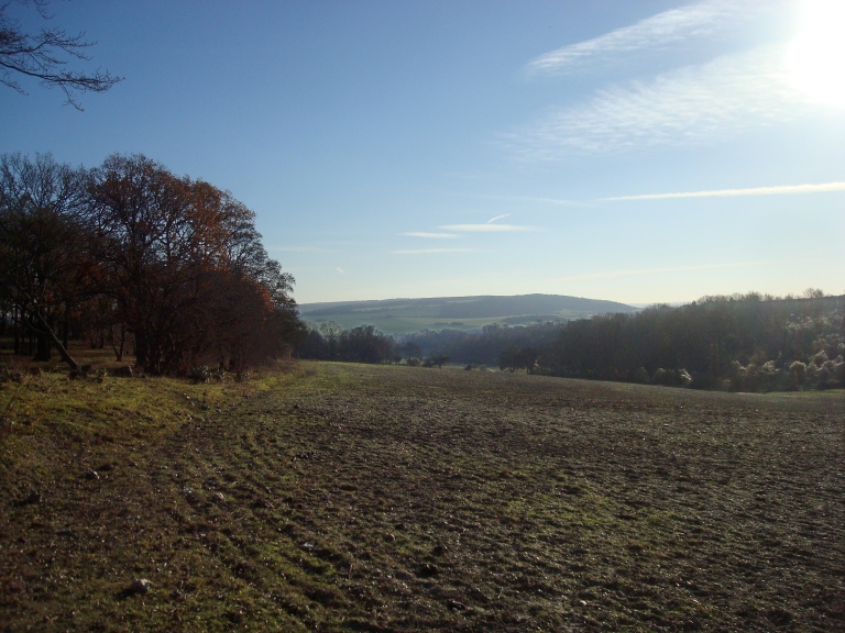
Mid-November brings the true onset of winter to the woods of Halling and Cuxton and the trees begin shedding their leaves as if they mean it.  Sycamores, maples and chestnuts usually lead the way, followed by elm, ash, and then finally the oaks and beeches.  Within a couple of short weeks, most deciduous trees are bare-branched, with just the beeches hanging on to a few brown leaves.


This opens up the shady woodland and makes things a bit easier to see, of course. And Stoneyfield House (or at, least, what is left of it) is something that becomes much more obvious in autumn.


Walking along the North Downs way from Church Hill leads through Mays Wood.  At the cross roads with the Warren, the North Downs way takes a sharp right and heads off down Bush Valley, but a good track continues on through into Wingate Wood, an older and once heavily-coppiced and managed piece of woodland.


Most of the larger trees in this area were lost to the Great Storm of 1987, and many of its victims still lie on either side of the path, the chalk-encrusted roots having been levered out of the chalk substrate to present themselves as white, ivy-encrusted tombstones, monuments to the forest’s loss.


Further on down the path, the woodland seems to be a little more sheltered, and many of the larger trees remain, giving a feel for what Wingate Woods must once have been like throughout.  Here, the oak and beech still had some green leaves to contrast with the gold, and even some of the ash and chestnuts are still holding on to a few leaves that their less-sheltered brethren elsewhere have long since lost.


At the clearing where the high-voltage cables cross above, Wingate Wood becomes Thistly Spring Wood.  This wood is similar in nature to the last part of Wingate Wood, with fewer coppices and more widely-spaced, larger trees.  About 500 yards in on the right, the remains of Stonyfield House can be seen through them, only about 10 yards off the main track.


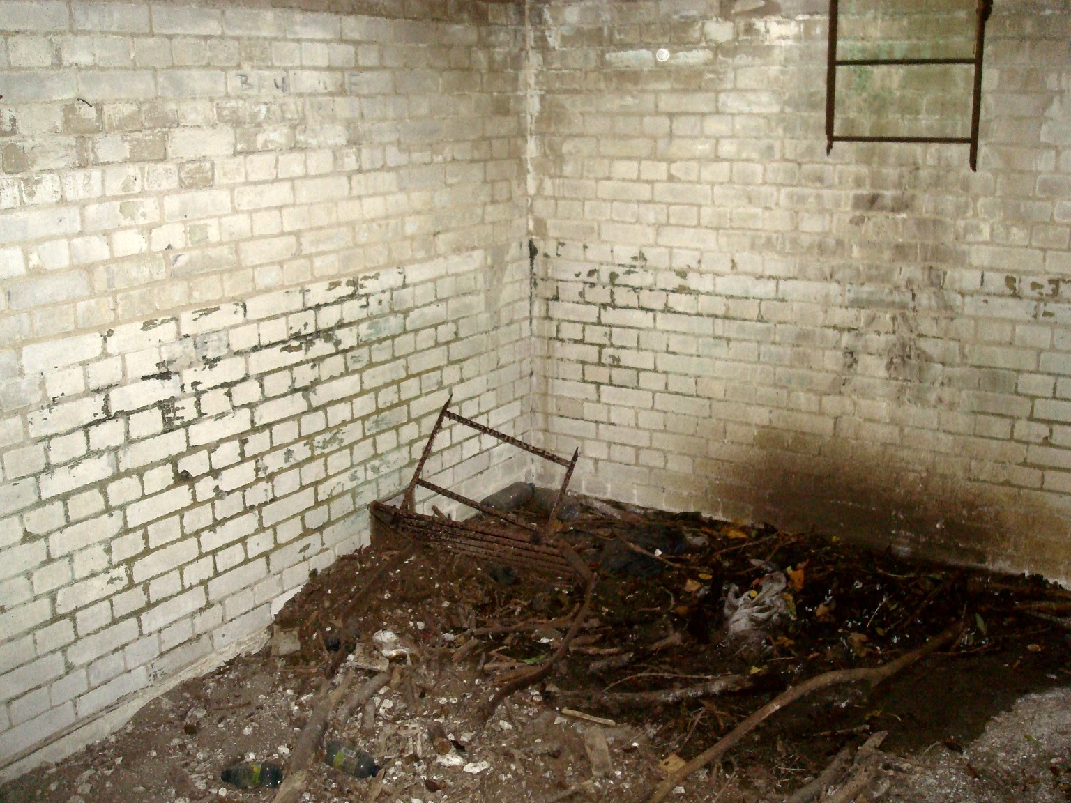
Little seems to be recorded about this isolated structure. Stonyfield House is referenced on Ordnance Survey maps, but in very few other places.  It is sited close to the open field of Stoneyfield Shaw and perhaps once overlooked Stonyfield Woods away to the west. 

The area to the north of the cottage was an open field at the turn of the twentieth century, as the 1908 OS map shows...

1908 OS map showing Stonyfield House (centre)...

The original structure must have been around 10 yards across on each side, with single-storey flint walls, although only the eastern side of the flint wall still remains standing.  On the west side, there seems to be some newer, crude brickwork added, and what little remains of a pitched roof on one side clad in corrugated iron, held up with a timber frame. 


On the north side there is a hand pump and well cover, with a pipe running into the ground. The presence of a well suggests that this lonely, isolated building might once have been inhabited. The pump itself is an Excelsior No.5 reciprocating pump: this brand has been in production since 1919 right up until today.


The only direct on-line reference to a structure with the “Stonyfield” name in Halling comes from a summary of a 1901 census. Back then, “Stony Field Cottage” appeared to be the home of Mr Alfred Wisbey, his wife Elizabeth and their seven (!) children. The children, four sons and three daughters, ranged in age from 3 to 16, with the eldest, Samuel, following his father’s profession as a gamekeeper.

Certainly the structure in Thistly Spring Wood could well be the remains of a gamekeeper’s cottage, but it seems difficult to believe that a family of nine could once have lived there.  Life must have been harsh for the Wisbey family indeed, if this was once Stony Field Cottage. They must have been resilient, hard-working people, living a life of hardship that we cosseted and privileged folk in modern Britain cannot begin to imagine.

According to correspondence on the “Old Pictures of Halling” Facebook page, the cottage was subsequently, for a while, home to Rodney and Jack Rodgers, both gamekeepers who worked for the cement company who owned the land. The shed at the side was used by Rodney (and, prior to him, by a Mr. Macmillan) to rear pheasants that were subsequently released for the shoot in the nearby hills.

A Mr. Jack Rogers at Stonyfield House (photo posted by Paul Bullivant on the "Old Pictures of Halling" Facebook page)

The picture of Jack Rogers above was apparently taken by a Mr. Ronald Homewood, who at one point had a vegetable garden up there. A sad story relates the tale of Mr. Homewood’s brother Bill, who apparently committed suicide at the cottage by taking the lid off the water well and drowning himself. By all accounts, Bill had gone up the cottage after a pint or two in the nearby Robin Hood pub, and went to pat one of Jack’s dogs that was asleep. Startled, the dog attacked Bill and tore off his lip. Bill was offered plastic surgery but, in a fit of depression, killed himself before he went for treatment. In the aftermath, Rodney Rogers took the unfortunate dog up to the woods and shot it.

Whilst not lived in, Stonyfield House appears to have been in use right up until the 1970s, with its associated garden still being tended, as this 1973 photograph appears to indicate...

"Ruins of Stonyfield House with shed and garden" (picture by Derek Church, 1973)...

The area is now overgrown and choked with brambles and bushes.

On the way back I noticed that in several places, "fairy rings" of mushrooms were growing up through the leaves on the woodland floor.  I think these might be Clouded Agaric...


I understand that Clouded Agaric are edible, but I really don't trust my fungus identification skills to the extent that I would actually try one.  Because they might be Brown Roll Rims instead... 

Sunday 14 October 2018

Beating The Bounds...

(Please note that for those interested in a more detailed history of the "beating of the bounds at Cuxton", I have now given the subject its own blog page - see the right-hand side bar on the home page)

A volunteer (not me) marking a parish boundary tree in Little Red Wood

This Sunday, I tagged along with some twenty-odd other individuals comprising of Cuxton Parish council committee members, councillors and some other interested folk for a "perambulation" of the Cuxton Parish boundary.

These days, Cuxton's beating-of-the-bounds is currently undertaken every three years or so by members of the local Parish Council and its supporters. The passage of time changes many things and indeed, the historic ecclesiastical connotations of the 2018 event seemed little in evidence, with this year's triennial perambulation starting from the car park of the White Hart on a damp Sunday morning in October, rather than during the Rogation week of May.

Whilst the modern parish boundary is well-indicated on today's Ordnance Survey maps, paths and land use and ownership have greatly changed the ability to physically get to it.

Cuxton Parish boundary (2015 OS boundary marked in blue, perambulation route marked in red)

Indeed, its south-east portion actually runs along the middle of the River Medway, somewhat hindering any form of access (although Mr.Church does give an account of his doing so in 1966 by means of a canoe!).

Starting from the White Hart, we made our way across the railway crossing and took the alley running to the railway underpass, this path being the nearest practical one closest to the river "boundary". From there, we walked behind Factory Cottages up to the motorway bridge, then along a track across a smallholding, through the gate (kindly left open for us by arrangement with the landowner) and on to Sundridge Hill, adjacent to the Cuxton village sign.


From there, we crossed the road into Ranscombe Farm reserve and took the track up through Meralls Shaw close to the M2.  The OS map shows the boundary as running on the other side of the M2 motorway, but is is neither safe nor practical to get to it.  From there, the path runs next to the fence safeguarding the Channel Tunnel rail track, on the eastern side of Magpie Shaw.

Derek Church references an account of a perambulation in 1796, which records some 55 parish boundary markers.  Two oaks and an ash tree were listed as markers on the edge of Magpie Shaw, but trees do not make for enduring sentinels.  Old age, thoughtless axes, disease (Dutch Elm and now Ash die-back) and the weather (and in particular, the storm of 1987) has seen the loss of countless trees in the area, and no trace of any markers were seen until we turned west from the railway down the path running along the northern edge of Stogarts and Drapers Wood.

Marker tree, Stogards and Drapers Wood

This was a recent example, bearing a record of 21st. century boundary walks and which was duly etched with this year's record.  The woods were just starting to show their autumnal colours.

Woodland track between Stodarts and Drapers and Broad Oak Woods

The track continued on into Birch Wood where a decrepit chestnut tree could still be found, very likely the one that was noted in the 1796 perambulation referenced by Derek Church.

Ancient chestnut tree, Birch Wood

A younger example of a boundary tree was found nearby.

Boundary beech tree, Birch Wood

We followed the track down to the Mausoleum, that wonderful but somewhat neglected folly that never got to be the last resting place of the local lords of Darnleys as its instigators intended.

Darnley mausoleum

From there, we dropped down through Norword Grove and took the path down to the railway underpass that led to Warren House.  The Parish Council had thoughtfully arranged for a couple of volunteers to set up a table or two with tea and biscuits there, which were most gratefully consumed in the onset of a chilly drizzle.

Sticking close to the parish boundary, the group crossed the road and walked across the field to the edge of Red Wood.  We tracked up the hill on the woodland edge, then took the track into Little Red Wood, where another marker tree was found and dated accordingly (see first photo above).  Here, one of the younger (and lighter) members of the team gamely volunteered herself to be "bumped" against the marker tree, in keeping with the rather strange tradition as mentioned above.

Available woodland paths then led us slightly westwards from the parish boundary into Luddesdown and along the edge of Wrenches Shaw down to Bushy Wood, where we picked up public footpath NS 214.

This took us down the valley through Halling Wood, slightly south of the parish boundary which runs along the bottom edge of Bush Valley field.  The OS maps indicate that some boundary marker stones are present there, and after a brief hack through the undergrowth we found a couple, marked with HA (for HAlling?), which are doubtless the same posts mentioned by Derek Church in his account of a walk in 1971.

Boundary stone, Halling Wood

After a hard slog up the steep side of the valley through Bavins Shaw to the northern tip of Stonyfield Wood, we were some way south of the actual parish boundary, but private land ownership and a lack of available paths dictated a pragmatic approach.  We took the path up through North Wood, which crossed the parish boundary again and took us north-east to Millgate Spring.  Here, we picked up a path that led south across the valley behind Dean Farm, and up onto the main path through Mays Wood, just above the Warren.  The paths runs slightly north of the parish boundary, which dips down through Bores Hole, across the road to Whornes Place and then down to the river.

Derek Church mentions some marker trees on the accessible northern boundary of Bores Hole, but by the time we got close by, the rain and autumn leaves had made the track too slippery for a safe ascent. We therefore decided to retreat down Church Hill and adjourn to the White Hart for a well-earned drink and (for some) a late Sunday lunch.

I intend to retrace this circuit at some point in the future, as I am sure that many of the markers mentioned in Mr. Church's account still exist, and it would be good to record precise locations of them.

Tuesday 9 October 2018

Lower Bush...

A view towards Bush Road from Upper Bush, in the late autumn sunshine...

Lower Bush...

Thursday 27 September 2018

Wrenches Shaw...

Following the footpath NS211 from Stonyfield Woods in Halling eventually leads you out into Luddedowne.

Location of Wrenches Shaw
The views from Wrenches Shaw across the valley are always worth taking in, although what the future will hold now that the land is under new ownership is uncertain.  There is a memorial bench just where the path leaves the woods.

Luddesdowne Church from Wrenches Shaw...

At this time of the year, some interesting fungi can be found in Wrenches Shaw...

Fly Agaric

Ringless Honey Mushroom...
Following the harvest, several types of wildflower can now be seen in the field edges by the woods...

Charlock...
Charlock (Wild Mustard) is often planted as a cover crop in winter.  I think the above is an example of Charlock, but it is apparently quite easily confused with other members of the same yellow-flowering cabbage relatives.  The seeds are poisonous - other species are used in mustard.  The leaves are apparently quite tasty, though - not sure I'd want to trust my own ID skills, however...

Borage...
Borage was traditionally cultivated for culinary and medicinal uses, although today commercial cultivation is mainly as an oil seed.  Borage is widely used in Europe used as either a fresh vegetable or a dried herb. As a fresh vegetable, it allegedly has a cucumber-like taste and can be used in salads or as a garnish.  I think I'll stick to cucumbers in salads, though...

Germander Speedwell...
This pretty little flower can be found pretty much all year round.  It can be distinguished from other speedwells by the double line of hairs which grow on either side of the main stem.

Scarlet Pimpernel...
The little red flowers of Scarlet Pimpernel were also in abundance.  The plants are poisonous, although as yet demands by morons to wipe them out have thankfully yet to be made...