The Toe Memorial - as it is now, and as it was 100 years ago...
The remains of the "Toe Memorial" today...
At the top of the path that runs to the west of Birch Wood, just
to the south of the parish boundary between Cuxton and Cobham, lie the remains
of a rather curious monument, locally known as the “Toe Memorial.”
Edward Bligh, 5th Earl of Darnley...
Hidden amongst a stand of yew trees, it marks the spot where
(so the story goes) Edward Bligh, the 5th Earl of Darnley, FRS, (b.1795)
received a self-inflicted wound that led to his untimely death at the age of 39.
As local historian Derek Church tells us:
“On 4th.
February 1835, Lord Darnley was walking in the [Cobham] Park with his cousin,
Charles Bligh, when they came across some woodcutters. Possibly thinking that
he could do better, Lord Darnley borrowed an axe and said ‘Now I’ll show you
how to cut a root in halves’. He struck a mighty blow that glanced off the root
and nearly severed his little toe..."
He started and said: “I have harmed myself, I fear! But it
might have been worse and I ought to consider myself fortunate…”He staggered to a nearby cottage just above the scene of the accident, where his foot was dressed.
The Earl clearly didn't take the accident seriously: only
the next day he wrote: “We are all well here, barring that I almost cut off a
little toe with an axe yesterday: providentially it is a matter of no
consequence, but might have been a serious accident...
But in the days before tetanus injections, such an
injury was a serious matter. This illness, (also known as
lockjaw) set in and a week after the accident, the Earl
died.
Edward Bligh, 5th Earl of Darnley...
His grieving widow, the Countess of Darnley, Emma Jane Bligh (nee Parnell), mother of Lord Darnley’s
five children, subsequently had the memorial built to commemorate the incident.
Some have written that the Countess Darnley’s shrine to her late
husband is a “monument to arrogance and stupidity”, but a little research soon shows
that the arrogance and stupidity lies only with those who would suggest such a
thing. Indeed, this slur has been thoroughly debunked by local historian Geoff
Ettridge in his excellent blog post on the subject (a link to which is given
below).
As Geoff tells us, the 5th Earl of Darnley was, by any
standards, a forward-thinking, honest, liberal man who was well respected by
all who knew him, and his sad loss was keenly felt by both his peers and his estate
workers at the time. To imply that he was perennially arrogant or stupid is a
grievous sleight, both upon the man’s character and to his memory.
The memorial, alas, has not withstood the tests of time.
Rather like the adjacent Darnley mausoleum (built in 1876 by the third Earl of
Darnley, Edward’s grandfather) it suffered extensive vandalism in the seventies
and eighties, but unlike the mausoleum, it has not been subject to restoration.
A photograph of the memorial from around 1920 shows the Toe
Memorial as it was in its original state (see below).
The Toe Memorial, c. 1920...
I suspect that the scrap value of its intricate metal railings may have been a big factor behind its subsequent destruction. There
is certainly no trace of them in the area now, whilst the carved stonework
still lies sadly scattered around the remaining plinth.
Debretts Peerage tells us that the Arms of Bligh (the
heraldic symbols of the Earls of Darnley) comprises of “Azure, a Griffin
segreant Or, armes and langued Gules, between three Crescents Argent. Crest: A Griffin’s Head erased Or.
Supporters: On either side a Griffin
wings expanded Or, ducally collared and chained Azure.”
I don’t have a clue as to what any of that means, but the gryphon
motif can be seen on one of the fallen stones, and features prominently above
the entrance to the nearby Darnley Mausoleum, as shown below…
Headstone from memorial bearing the Darnley heraldic gryphon...
Heraldic Darnley gryphons above the Mausoleum entrance (N.B. Finem Respice: Consider The End)...
Perhaps one day the Toe Memorial will be restored to its
former condition but for the moment, it remains one of Cuxton’s many hidden and
intriguing gems.
References:
1)Cuxton: A Kentish Village by Derek Church (published by Arthur J Cassell Ltd, 1976, ISBN 0 903253 12 7), p 18.
2) "Memorial to Lord Darnley's Toe",Geoff Rambler's Weird and Wonderful Kent, blog post by Geoff Ettridge (link here).
3) Lost Landscapes - Cuxton Heritage Trail (link here).
Tucked away on the hill on the western Cuxton parish
boundary, just above the point where Bush
Road becomes Warren Road, lies Warren House. Until
quite recently this was the home of Abbeymount Kennels, but the kennels have now closed down. It is a pleasant, modern-looking house (see below), built in 2010, close to the site of a much older cottage that served as a gamekeepers lodge for workers tending the
Darnley estate over the hill in nearby Cobham.
Warren House - as it is today...
The original building was a single storey flint cottage,
with a steep thatched roof and a distinctive arched door and windows in the
“Gothick” style. I am not sure exactly when it was built, but a census taken in 1841 shows that Warren House was then the residence of a Mr. Joseph Ricketts, gamekeeper. Warren House features on an
1869 Ordnance Survey map of the area (shown below) but not on an earlier (though rather crude) map of 1769, so it would be
reasonable to assume that it was probably built in the early part of the 19th century.
A photograph taken in the early part of the 20th century shows gamekeeper John Griffin and his young son, Ron, in front of the original cottage (see below).
Gamekeeper John Griffin and his son, Ron, outside Warren House, 1908...
The OS map of 1895 (see below) showed a phesantry to the rear of the
cottage, where pheasants were reared for the Darnley
estate shoot.
Brood hens were used to hatch the pheasant eggs, hence the
scene in the photograph below.
Warren House pheasantry, c 1912; L-R, Ron Griffin, John Griffin, Joe Cogger, Charlie Ashenden...
Dormer windows were added to the cottage in 1914 (see below)
to give light to bedrooms in the roof, doubtless added to make a bit more room
for the Griffin’s growing family.
Warren House, c 1920...
The Griffin family lived in the cottage until 1923, until a
spark from the chimney set light to the thatched roof and the cottage burnt
down. The Rochester Fire brigade attended but the cottage well had run dry and
water had to be pumped from the forge down the lane. The Griffins stayed in
Bush until the cottage was rebuilt, with the new cottage reconstructed much in the
style of the old one, but with a tiled roof. The cottage well was back-filled
in 1938, when mains water became available.
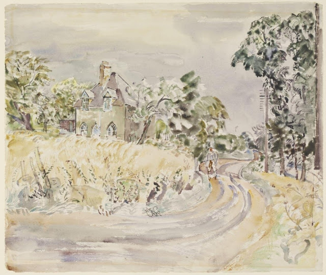
A watercolour painting (held in the Victoria and Albert
Museum) shows the cottage as it appeared in 1940 (see below).
"Gamekeepers Cottage, The Warren House, Cuxton Valley", by George Hennell, c.1940...
The cottage looked much the same in 1971 (see below)...
Warren House, 1971...
The attractive flint walls appeared to have been rendered as part of the rebuilding work after the fire, but the "Gothick" arched windows and door were retained.
The kennels appear to have been given planning permission in 1995, and closed only recently.
By 2007, Warren House had been modernised and extended at the side and rear. Planning permission was sought in 2007 to build a 40% larger dwelling on the same plot just above the existing cottage, but was refused by Medway Council due to green belt considerations and the size of the proposed new cottage!
Obviously, Medway Council's planners are far less concerned about the green belt these days, given that they have become passionate advocates for a 16,000 m2 (!) billionaire tax exile's vanity winery at Upper Bush!
After reducing the size of their proposed new bungalow, planning permission was granted to the applicants in late 2010. However, Medway Council's (now non-existent) determination to protect the green belt led to them to specify that the old Warren House had to be demolished, so that there could not be two dwellings on the site.
Construction of the new Warren House in 2011: the original (on the right) was demolished shortly afterwards...
Despite opposition from Cuxton Parish Council, the cottage was demolished in 2011, and so Cuxton lost another of its few remaining historic buildings.
References:
1) Cuxton: A Kentish Village by Derek Church (published by Arthur J Cassell Ltd, 1976, ISBN 0 903253 12 7), pp 76-77.
What Vineyard Farm's new restaurant complex may look like at night...
In previous posts I have described how the Vineyard Farms planning proposals for a new country club and restaurant in Bush Valley are primarily based on sophistry and inadequate and distorted data. The Ecological Impact assessment doesn’t quite fall into either of those categories, but, rather like the traffic survey, it looks to be limited in scope and with serious omissions. It seems that the assessment refers only to the impact on the immediate area of the site, as if somehow the site exists in complete isolation from the habitat around it. Both the Environment Agency and Natural England have nodded the assessment through, but only on face value as they rely solely on the assessors to flag up any issues.
The site itself is historically arable farmland, and so it
would not be expected to harbour permanent populations of wildlife. Similarly,
the band of scrubby woodland to the north of the site scheduled for hacking
back is only around 40 years old and (from my own walk-around in it) I would agree
with the survey when it says that it is nothing special. (Update: as an antidote to my lamentable ignorance about the value of this "plantation" woodland, please see p.20 of the "Community Insight" document. It is far more valuable than I thought...)
The winery development site is in close proximity to SSSI
sites to the south and west, however. Whilst these are acknowledged by the
assessment as existing, the long-term effects of the construction and operation
of the restaurant and entertainment venue upon the adjacent wildlife is only
mentioned in passing.
Hypercallia Citrinallis
The extensive Halling and Trottiscliffe escarpment received
its SSSI designation because of the presence of rare insects and orchids. The
survey does not consider the impact that Vineyards Farm’s new country club
could have on the nearby SSSI woodlands and its wildlife.It mentions in passing the rare moth Hypercallia citrinallis (found nowhere
else in the UK) and yet the assessment made no attempt to see if it was
present, even in transit, on the site. A simple night-time moth trap could have
been used.
Both the lighting assessment and Foster & Partners
Design and Access statement show that the restaurant building will be lit up
throughout the night.At the moment this
is quite a dark site, largely sheltered from the lights of Cuxton and further
afield by woods and hills. Given the elevated position of the Vineyard Farms’
new country club on the top of Barrow Hill, however, it is going to act like a
giant insect trap in Bush Valley when lit up at night.The adverse affects of artificial lights upon
wildlife are well
known yet the assessment fails to mention it.I wonder why?
Red Wood, looking south from fields above Warren Road...
I was also very surprised by the bat survey results. Back in
2017 I witnessed dozens of noctule bats (Britain’s largest bat) flying around
Bush Valley, and yet the survey in 2021 found not much bat activity (though
there were apparently some “big” bats around that the survey couldn’t name!). It seemed that they suffered from mysterious
technical failures of their recorders and no attempt was made to repeat the
work due to the rushed nature of the assessment.
This lack of bats led me to go looking for the noctule bat
roost that I had been shown at the northern end of Red Wood. Historical records of bat surveys in the area
showed no evidence of the roost I saw, but then I certainly never brought widespread
attention to it (I don’t count this blog as nobody reads it) and neither would
my bat-hunting companion have done (and indeed, we have seen what happens when
you advertise the presence of our wildlife to the wider “community”…).
Unfortunately, I found that that area of Red Wood has recently been
coppiced (long overdue, to be fair). I certainly couldn’t find any evidence of the rotten old chestnut
trees that were the roosting trees, but to be fair I am not 100% certain they
were in the area where the coppicing has taken place. It is illegal to disturb
bat roosts, but Tilhill (the woodland contractors for Vineyard Farms) are a
highly professional crew and I have no doubt they would have spotted the roost
if it was there.
Northern part of Red Wood, recently coppiced...
It seems likely that the coppicing activity would have
disturbed any nearby bats though, who would have just flown off elsewhere.
If you want to make an objection to the council about
Vineyard Farm’s proposal, then you are running out of time (closing date September 22nd.)
As an aside, I have been rather surprised to see the degree
of on-line hostility directed towards those of us who have taken the considerable
trouble to read through the hundreds of pages of planning application documents and
analyse them in detail. I came into this with an open mind, hoping to see a
sound justification for the project. I really, really like Lord Foster’s
design. Instead, the submission has been shown to be a rather disappointing collection of half-truths and distortions,
some of which could have a significant negative impact upon the village of Cuxton. I thought local folk would be
grateful for our efforts in calling all this out.
Instead, we have been decried as NIMBYS, whingers and (my
favourite) “fluffy hand wringers”. I’m not going to respond to that. After
all we live in a democracy, where one person’s angry, self-centred ignorance is
equivalent to another’s knowledgeable attempts to educate and inform.
I look forward to seeing a reasoned, well-argued case in
favour of Vineyard Farms’ plans. It isn’t in their planning application as yet.
And it certainly won’t be put together by some of the Facetube/Twitbook brigade,
who prefer lazy insults to the hard work of actual research and careful, documented
argument…
In my last post I explained how the Vineyard Farm planning
application to build a country club-style winery in BushValley
is effectively based on smoke and mirrors.
My objection on that point is really one of principle: plonking new buildings in green belt land is simply not permitted under
existing planning regulations.
It looks like most people in the area don’t really care about
that, however. Most local people don’t take walks in our wonderful countryside in Bush Valley, it
seems. Vineyard Farm’s plans for Upper Bush don’t directly affect them, so
they’re not bothered.Oh, it might even
be a nice place to go for a meal, they’re thinking. It will even create jobs (how many local, I wonder? Enough to offset the local job losses that occurred when Vineyard Farms bought out Court and Brookers Farm and then Bush Farm?).
But this post is going to concentrate on how the winery development will directly and adversely affect all residents of Cuxton.
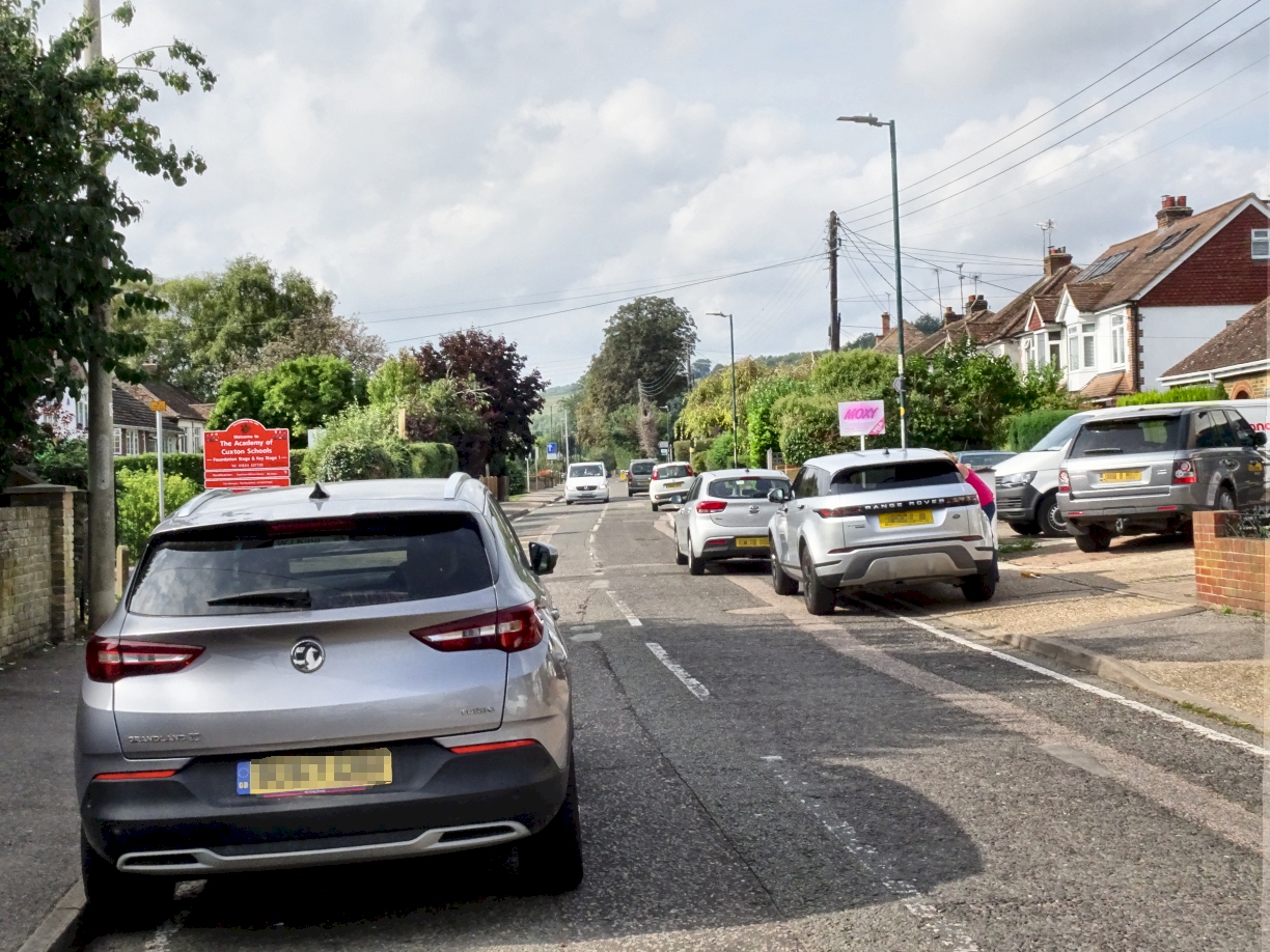
Everyone who lives in the village knows how congested Bush Road can get,
especially at school run time. It is effectively a single track road, with three
chicanes and lots of on-road parking that makes HGV and delivery driver’s lives
pretty difficult – especially at school run time when Cuxton Primary empties
out.
Parking on the main road by the Co-Op. Note the bus stop parking - so much for public transport...
The proposals put in by Vineyard Farms (see the Framework
Travel Plan on the council’s planning web page) freely admit that around 70,000
visitors a year will be going to the winery. The site will also employ around
150 winery and estate workers.
We all know how poor public transport to and from Cuxton is.
We all know most of these visitors and staff will be driving to the winery.
The Outline Deliveries and Servicing Management Plan tells
us that around 850 HGVs a year will be going to and from the site. There will also be
waste collections and deliveries of goods via non-HGV vehicles.
It all adds up. It’s all additional traffic trying to
negotiate the three chicanes (where the road has been narrowed at the bottom of
Wood Street,
by the social club, and just up from the bottom of Charles Drive) and the resident’s cars
parked by the shops and further along the road.And that's without the cars parked up during school run time.
Bush Road
is already heavily congested. Anyone who walks along it, pretty much any
time, can see that.
Parking outside school, non-peak...
And yet the Transport Assessment concludes in Section 2.23
that“that traffic flows on Bush
Road are low”…
This defies all common sense and even the most casual of
observations. How on earth does it come to that conclusion?
Simple…
Section 2.21.states that vehicle count data was gathered
from an area adjacent to the Dean Farm access road. This is a completely inappropriate place to conduct a traffic survey if
the true extent of congestion in Bush Road is to be assessed. Congestion in
Bush Road occurs primarily between the school and the A228 junction and this is
where interactions of new facility traffic with existing traffic are likely to
occur.The data in the survey is skewed because it effectively excludes much
of the existing traffic.
Section 2.22: Peak times for traffic are given as 8-9 a.m
and 5-6 p.m. This is also wrong, as the traffic congestion in Bush Road is primarily
driven by the “school run” times, which are 8.15-9.15 a.m. and 2.30 – 5.00 p.m.
The conclusion in
2.23 that “that traffic flows on Bush Road are low”
is therefore based on completely unrepresentative data.
2.24. Given the above poor choice of the traffic survey data
collection point, HGV movements have also been severely underestimated as many
HGVs are deliveries to Cuxton village that will run up James Road, or to the Co-Op, well before
the data collection point.
Given that the
traffic survey data is derived from the wrong place and the wrong times, any
conclusions drawn are effectively meaningless.This survey has to be repeated in a proper manner before any compliance
with consent conditions can be assessed.
Social club chicane...
There is another omission in Meyer Brown’s Transport Assessment.
Section 4 of the Transport Document attempts to justify the
development in terms of manufacturing process logistics. It claims that the grape
processing, fermentation and bottling process has to be conducted local to the
vineyard for quality considerations, and that therefore the wine factory has to
be built at Upper Bush.
It ignores the obvious logistical solution. Crushing the
grapes on site (to reduce possible bruising and oxidation damage to the fruit
if otherwise transported) could take place in very modest facilities, possibly
even existing ones at Court and Brookers Farm in Luddesdown. Based on 900 acres
with a 3 ton per acre yield, it would subsequently need only approximately 90
tanker movements to transport an entire annual juice harvest to a local business
park that had a fermentation and bottling plant built there, with access that allows easy delivery of bottles and process consumables,
and distribution of finished product.
As stated earlier, the Meyer Brown documents suggest 850 HGV
movements a year in the proposed facility. The alternative, completely
unaddressed by any of the submission documents, reduces this enormously.
It must be emphasised that were this activity to be
primarily focussed upon the production of bottled wine, the fermentation and
bottling operations would take place at a facility with better transport access
than that offered by Upper Bush – and one that would not cost £30m.
This option has not
been discussed at all in the proposal.
Charles Road chicane...
And so it goes on…
In terms of access to the proposed development site
post-construction, it is worth noting that section 3.25 of the Mayer Brown
Transport Assessment admits that the site accessibility index is zero, due to its rural location away
from major roads and its poor access to public transport.
The document then attempts to describe Cuxton’s
accessibility by means other than a car as meeting national and local planning
criteria for accessibility. This is not supportable. Bus and train services do
not directly connect with any major transport hub, with drop-off points located
well away from the proposed facility.
The Outline Delivery and Services Management plan is also
flawed. It states (1.11) that 3 HGV
deliveries will be made per day for import and export. This does not allow for the seasonal nature
of the business. If we assume this means
“3 per working day” then this means approximately 750 HGV vehicles to site per
annum (or 1500 HGV transits), with the majority arriving in 3 months over
harvest time. If we assume that 75% of
HGV deliveries are seasonal, this means that around 10 HGVs per day will be
arrived at peak season.
HGV deliveries will supposedly be restricted to 6-7 pm and
4-5pm. The latter times clearly clash with school run times. This also indicates that morning deliveries
will be made at anti-social times (defined as operation outside of normal
business hours by both trade unions and mental health professionals).
Sections 1.15-1.21 rely entirely on the goodwill of delivery
drivers to minimise site nuisance noise arising from deliveries and do not say
what action will taken to enforce compliance.
So, villagers of Cuxton, if you ignore this one, then you
really can’t complain in the event that the tourist and vineyard maintenance
traffic clogs Bush Road and turns any journey to or from your home into a logistical
nightmare.
The plans
for theVineyard Farms wineryfor Upper Bush in Cuxton have
now finally been put up on Medway Council’s planning portal. Just put the word
“winery” into the search panel and you will have access to the thousand or so
pages of assessments, planning statements and (of course) all of the glossy brochures provided by Foster and partners for the
breath-taking flying saucer they want to crash in one of Medway’s last bits of
green belt land.
The
response deadline is next Wednesday September 22nd so you haven't got much time to comment on it.
I’ve had a
good read of most of it, though.
All I can
say is that in a fair and just world, this
planning application should have been laughed out of
the planning office during the pre-application stage. (But of course, it’s Medway Council we are dealing with
here, with their vainglorious dreams of city status…)
The absolute, unavoidable reason why this application should have been kicked straight out by Medway Council is that building new buildings on green belt land is still pretty much forbidden. End of.
No argument.
The
National Planning Policy Framework 2021 sets out what the Government’s planning
policies are for England and how they should be applied. Section 13 details
protections for Green Belt land (in which the proposed development lies) and
paragraph 149 is unequivocal:
149. A local planning authority should regard the
construction of new buildings as inappropriate in the Green Belt.
It is noticeable that the
Shrimplin-authored Planning Document refers to many sections of the NPPF and
other planning guidelines, yet funnily enough, it fails to mention this one. The biggie. The "er, we're not really allowed to do this, are we...?" one.
In desperation, the Vineyard
Farm application to build on Green Belt land relies on claiming that the winery
building is an “agricultural” development and is therefore exempt from Green
Belt/ANOB planning restrictions.
This is complete and utter
rubbish; indeed, the Planning Statement tries to pass off Lord Foster's
spectacular £30m design as some sort of farm shop! The proposed winery building is, first and foremost, a sophisticated
entertainment venue with a “visitor’s centre” comprising of a large restaurant, bar
and café. It will be used primarily by
visitors and restaurant customers – how can they claim it is an agricultural
building?
Foster & Partners own series of beautiful, highly
impressive but desperately superficial “Design and Access Statements” (and in
particular, Volumes 3, 4 and 5) show the emphasis that is being placed upon the
visitor reception, restaurant, café, retail and wine-tasting areas. It is
absolutely clear that the basement production facility, although large, is very much
secondary to all of this.
How many farm buildings have a 31,000 litre ornamental lake
as a fixture, I wonder? (As an aside,
I’ve wondered about that lake. It seems quite fashionable forbillionaires to want to fly rocketsthese days. Maybe the owner of Vineyard Farms, Mark Dixon, has similar aspirations…?)
Anyway...
The staffing level for the whole building is stated to be
around 50 FTEs and although the planning document is careful not to
mention it, the transport documentation tells us that the staffing of the production area is 10 FTEs. This alone gives the lie to the argument that the hospitality operation
is “ancillary” to production. If your staffing levels are 4 hospitality
guys to every one production worker, where does that show your emphasis to be?
To try and prop up this paper-thin case for exemption to
Green Belt planning rules, Shrimplin also cites a legal precedent where
planning permission for a wine plant was given in a green belt area (Millington
v. Secretary of State for the Environment). The similarity of that
development to this one being put forward by Lord Foster is pretty much zero
and, I think, would be laughed out of court were it used to try and overturn
what should, in a just world, be a straightforward rejection of these plans by
Medway Council.
This single factor should be enough to kill this planning
application stone dead. Foster’s Flying
Saucer is not an “agricultural building”. It is not a farm shop. It is a vainglorious visitor’s reception/wine
bar/restaurant/café-style country club that just happens to have a wine plant in the basement.
It must also be emphasised that were this activity to be
primarily focussed upon the production of bottled wine, the fermentation and
bottling operations would take place at a facility with better transport access
than that offered by Upper Bush – and one that would not cost £30m. Crushing
the grapes on site (to reduce possible bruising and oxidation damage to the
fruit) could take place in very modest facilities, possibly even existing ones
at Court and Brookers Farm in Luddesdown. Based on 900 acres with a 3 ton per
acre yield, it would subsequently need only approximately 90 tanker movements
to transport an entire annual juice harvest to a separate fermentation and bottling plant built elsewhere, maybe on a local business park with
access that allows easy delivery of bottles and process consumables, and
distribution of finished product. This would eliminate at least half of the HGV
movements in Cuxton that would otherwise result from the existing proposals.
This option has not
been discussed at all in the proposal, because it would negate the need to
build the large facility they want on green belt land in Upper Bush.
If the spurious nature of the
claim that the development is primarily an “agricultural development” is
recognised, then the submission meets none
of the other criteria cited for permitted development within green belt
land/AONB. Assertions of conformance made within the Planning Statement are
completely and demonstrably baseless.
And, villagers of fair Cuxton, Luddesdown and Halling, you need to be shouting about this outrage from
the rooftops. You must not be seduced by Lord Foster’s glossy brochures, or the
promise of a swanky restaurant on your doorstep, or even a bit of local discount on the wine they are planning to make.
These plans are a stalking horse.
In Section 2 of their Design and Access Statement, they
boast that:
“The planning application for the Kentish Wine Vault forms the first
project of an estate-wide strategy for Vineyard Farms Ltd that will evolve in
subsequent years across it’s (sic)
Luddesdown and Upper Bush estate”...
If they get planning permission to build in the green belt, it will open the
floodgates not just for development in Bush and Luddesdown Valley, but in every
bit of green belt land in the country.
It’s a test case, being closely
watched by Boris’s building chums everywhere, who
are licking their chops and rubbing their wallets in anticipation of developing the UK’s green belt for cash. If
Vineyard Farms get their way, it will set a national precedent. This would be
just the start.
"Oh, we've bought a wine kit from Boots and we'll put it in the cellar of our proposed shopping centre, because that makes it an agricultural building" will be the next stretch of the argument. Maybe followed by "little Johnny might grow some mustard and cress on a bit of damp kitchen towel in his bedroom, so can we call this housing estate an agricultural development, please...?" There's just too much money in development land these days to rule out any argument in favour of building stuff as fatuous. Big companies can pay clever lawyers fortunes to argue that black is white. Killing folk on zebra crossings doesn't matter to them.
So, Cuxton/Halling/Luddesdown
villagers, you have to speak up, not just for yourselves, but for everyone. Get
engaged. You owe it to yourselves, your kids and your grandkids. We can’t let
Foster and Partners build on our green belt land. We simply can’t. Please, please, go
on to the Council planning web page, find the application (MC/21/2328, or type in "winery" as described above), click on "comment" open an account and register your
objection to this scheme. Yes, it's a faff but you have to do it. Or just write a letter to them.
This has to happen by September 22nd.
Tell them that the Vineyard
Farms proposal must be rejected because it is inappropriate for Green Belt
land, as spelt out unequivocally in paragraph 149 of the National Planning
Policy Framework 2021.
Tell them that the case made for
an exemption to Green Belt planning restrictions, based on the assertion that
the winery building is primarily an agricultural building, is clearly unsupportable.
Say that the Foster and Partner Design and Access statements clearly show that
the prime function of the proposed facility is that of a hospitality venue (of a
nature of which Kent is already well-served by) and not a wine manufacturing
plant.
Tell them that no consideration
has been given to a proper agricultural business-based process flow assessment
(which would logically conclude that the fermentation and bottling operations
should be conducted elsewhere due to access and transport issues) solely
because that would undermine the case for the proposed scale and design of the
visitor’s centre in green belt land.
Tell them that Vineyard Farms
shouldn’t be allowed to fly Thunderbird One out from under that lake (no, don’t tell them that, I made that up. Mind you, it’s no more ridiculous than a lot of the stuff in the Vineyard Farm proposals).
If you love Cuxton, Halling and
Luddesdown, its beauty, its peaceful woods and farmland, its wildlife and its
scenery, you have to oppose this planning application. You have to make your voice heard.
If you don’t, our children and grandchildren will look back at pictures of how it all used to be and will never forgive us. "Grandad, what's a tree...?"
Please watch this space. I have
more to say about the traffic and the environmental assessments in my next posts.
It seems that the pleasant little village of Cuxton is under
attack like never before. Earlier this year, we learned that an overseas tax
exile wants to plonk a vainglorious restaurant and visitor’s centre on top of
Barrow Hill in Upper Bush, an act of green belt vandalism that has been met by
a tidal wave of complete apathy by most Cuxton residents.
Now it seems that Cuxton Church (along with all little
parish churches right across the country) is under threat of closure and
sell-off by the Church of England.
So how is this happening? To summarise:
The Mission and Pastoral
Measure (MPM) 2011 is a piece of legislation that sets out the legal procedure
for Church of England parish reorganisation and for closing consecrated church
buildings and settling their future.
Recently, the Church
Commissioners (the body which administers the property assets of the Church of
England) conducted a review of MPM 2011 and published a proposal (known as
GS2222) for “simplifying” it.
In summary, these proposals
(discussions of which will close on September 30th this year), would
empower dioceses (the offices of the regional al bishops and archbishops) to
take an axe to the present local parish system. They would effectively
short-circuit the current review and consultation processes related to church
closures and remove any input or objection to a church closure from the local
parish clergy, the parishioners and the community at large.
Essentially under these
proposals, a diocese could unilaterally decide to close any local parish church
and dispose of it and its assets, and there would be very little the local
community could do about it.
This is an outrage. Most people in
Cuxton may not be regular churchgoers, but many of them care deeply about
Cuxton Church, its history and its role in the village of Cuxton. It was built
on the remains of a Roman villa and has been a place of worship for at least a
thousand years. The church is, however, much more than just a place of worship.
Its endurance gives a sense of place and continuity to the local community of
Cuxton: a village without a church is a village without a heart.
St. Michaels and All Angels
Church is loved and cherished by Cuxton village, and many of its residents
invest their own time and money in its upkeep without being regular
church-goers. For example, the eighteenth-century church organ had recently
fallen into disrepair and required an extensive re-build, with an estimated
cost of £50,000. Whilst the diocese contributed some funding, the bulk of the
money had to be secured elsewhere and indeed, was subsequently raised within a
few months thanks to the hard work of volunteers.
The bell-tower is similarly
maintained and operated by volunteers. When bell-ringing practice recommenced
in July after 18 months upon relaxation of Covid restrictions, the outpouring
of appreciation and support from the local community that the sound of the
bells drew was overwhelming.
The local community is fully
invested in Cuxton Church. It is completely unjust that it could be closed and
taken from that community, and on the mere whim of the Bishop and their staff,
depending on their latest “mission” or a perceived need to fund a fashionable
project elsewhere.
The joyous sounds of the
church organ and the church bells must not fall silent for such reasons.
If the Church of England
were impoverished, the desire to close churches for cost-control reasons would
be reasonable. But it is not. Since 1993, the value of the assets managed by
the Church Commissioners has grown from
£2.4 billion to £9.2 billion. In 2020 alone (a year blighted by the
pandemic) they grew by £500 million. Indeed, the post of Personal Assistant to
the Archbishop of York (a lay position) was recently advertised at a salary of
£90,000 a year!
Instead, these reforms are
being pushed through by the Church of England’s dioceses for their own
convenience. They are being made without proper and timely advance consultation
with clergy, parishioners, or groups who use church buildings.
So what can you do about
it? Not much, but if you care, you can
at least make your voice heard. You have
to do this by the end of this month.
You can write to the Church
Commissioners review body at mpm2011review@churchofengland.org , (clicking on the link should open your e-mail with the address already put in, but you can otherwise just copy the e-mail address and then paste it into the address box of your e-mail) perhaps citing some of the above arguments, and ask for the Church’s
legislative proposal GS2222 to be dropped immediately.
You can also write to your
local MP (in Cuxton and Halling’s case, Kelly Tolhurst, at kelly.tolhurst.mp@parliament.uk),
again citing the arguments above and
asking her to support her constituents in Cuxton and in Halling, by writing to
the Second Estates Commissioner, Andrew Selous MP, asking for the Church’s
legislative proposal GS2222 to be dropped.
Don’t forget to put your
name and postal address in the e-mail somewhere: that makes sure the recipients
know you are genuine, and are compelled to respond.
Please e-mail the church and our MP about
this. We have to try and save our
churches. Or a thousand years of history
could get sold off…