 |
| Ordnance Survey Map of Wouldham, 1909, indicating pubs and clubs... |
The 1909 Ordnance Survey map for the Wouldham area shows two
pubs in the village; the Waterman’s Arms and the Medway Inn. Outwardly, it
would appear that with respect to pubs as least, little has changed: both pubs are
still (thankfully) trading.
Wouldham, of course, has greatly changed in the past hundred
years. Little is left of the Wouldham
Court Lime and Cement Works that used to dominate the village back then, and (as
has happened throughout the area) many other buildings have been demolished and
replaced by newer houses.
The map does not tell the full story with respect to pubs in
Wouldham, however.
Although it seems hard to believe, Wouldham once supported as
many as six pubs - although one of those seemed to be a rather
short-lived enterprise.
This was
called the Black Robin (1), and was a little out of the main village up on the Pilgrims Road at the top of the footpath leading down onto the High Street. Little is known about the pub, which was open around the
mid-nineteenth century but had closed by 1870. It is thought that it
suffered a fire and underwent subsequent repair work. When the landlord, a Mr. "Basher"
Boorman, then applied for a new license, it was refused. The Maidstone Telegraph for 11th September 1869
tells us that:
“On Thursday, the
county magistrates sat for the purpose of granting licenses to beer-houses. There
were present the Earl of Darnley, Rev. J. J. Mafsham, T. H. Baker, Esq., Rev.
A. Smith-Masters, and Col. Bingham, C. B.
All the applications
were granted with the exception of the following:-
The following
applications for renewals were refused:- .... "Black Robin,"
Wouldham; ....”
Apparently, local farmers had complained that the pub
customers trampled on the crops on their return from the pub to the village…
 |
| The former Black Robin pub, date of picture not known... (Image from dover-kent.com) |
The handsome double-fronted building is still there as a private dwelling, at the northern end of Medway View terrace on Pilgrims Road above the main village.
 |
| The former Black Robin pub, July 2022... |
Just down the High Street from
School Lane is the Waterman’s Arms (2). Dating
back to the mid-19
th century, this Shepherd Neame pub is still open
(link to web-page
here). It is an imposing brick building, with a high-ceilinged bar so characteristic of Edwardian-era pubs.
 |
| The Watermans Arms, July 2022... |
In 1845, a Mr. William Langford was the landlord. He was then followed by three generations of the Baker family.
The pub was completely replaced in 1910 by the current building. During demolition, a double roof-space was discovered, used for smuggling liquor and apparently linked to the Robin Hood pub on Blue Bell Hill above Burham.
 |
| The then newly-rebuilt Waterman's Arms, c.1919. John Dobson was the landlord from 1913 to 1922... |
 |
| Watermans Arms, c.1933. The landlord from 1930 to 1938 was a Mr. Harry Sands... |
There used to be a large beer garden to the south of
the pub, but this has since been built on with a row of new terraced houses. The 1909 map suggests the pub was also once equipped with a
stable block, and doubtless served as a handy watering hole for workers at the
nearby wharf and cement works. The stables may have gone but the pub building remains virtually unchanged (though the side door and window were swopped round when the Saloon and Public Bar became one).
Heading further southward down the High Street, there is a
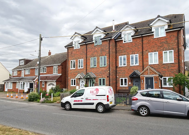
(now closed) corner shop. Just before the shop, there is a row of new houses,
one of which is 140 High Street.
I believe these houses were built on what was once the site of the Rose and
Crown (3).
 |
| Site of the former Rose and Crown pub... |
 |
| Rose and Crown, c.1950...(?) |
 |
| Rose and Crown, at a time when it was closed but still standing, date not known... (image from Wouldham Village History) |
Again, not much about the place is on record. A Mr. Jacob Vallins was listed as the licensee
as long ago as 1850, with (presumably) his son acting in the same role in 1891. Ind Coope & Co Ltd purchased the pub from Budden &
Biggs Brewery Ltd by conveyance and assignment dated 23 March 1931. The pub
held a beer only license. At one time and just after the local Co-op closed, the pub
used to house the local post office. During the 1960s the pub housed the local
youth club in their large hall on the 2nd floor.
 |
| The Dog and Partridge, July 2022, now a private house... |
A little further down on the left of the High Street (just
before the turning for Walter Burke road on the right) there is a small plaque
on the wall of No. 118 High Street that tells you it is (or was) the Dog and
Partridge (4). The pub closed in 1915 when the last two licensees died at the
age of 90. They were Mrs. Styant and Mrs. Ransley, life long friends. Nothing
much more is known about it.
Further down the High Street, opposite the top of Ferry Lane, lies a row of large white town houses, 70, 70a and 70b High Street. These houses used to be the Forester’s Arms (5), which only closed fairly recently.
 |
| The Foresters Arms, July 2022, now private houses.. |
Another pub with a long but little documented history, a Mr. James Peters was listed as the licensee as far back as 1861. The
Wouldham Village web-page is no longer updated but contains
some information on the Forester’s, which was certainly doing well in 2009. However, in 2010, a
stabbing outside the pub seemed to catalyse its closure and the pub was finally sold for redevelopment as houses in 2014.
 |
| Wouldham High Street, c.1910, with the Foresters Arms on the left... |
 |
| Foresters Arms, closed as a pub but signs still up, 2015... (Image from dover-kent.com) |
The final pub on our trip through Wouldham is the Medway Inn
(6), the second of Wouldham’s two remaining pubs (link to web-page
here) on the junction of the High
Street with
Knowle Road.
The pub has been trading since at least 1870, when a Mr. George Higham was the
licensee.
 |
| The Medway Inn, July 2022... |
 |
| The Medway Inn, c.1950... |
Finally, the map of 1909 above indicates a club (7), on the opposite side of the High Street just up from the Medway Inn. The building is still in use and currently serves as the Wouldham Village Hall...
 |
| Wouldham Social Club, now the village hall |
It was still indicated as a club on the 1939 revision of the local Ordnance Survey map, though when it ceased being a club I do not know. In the recent past it has acted as a scout hall and a library and is currently home to a pre-school club for young children.
Little readily-available information exists, but it seems likely that the Wouldham Court Cement Works just down the road endowed its local workers with this club, in much the same fashion as Hilton and Anderson over the river in Halling looked after the welfare of its workers by provision of the Institute.
References:
DoverKent.com
Wouldham Parish Council
Wouldham Village History
Wouldham Village


